Even experienced hikers can struggle when a trail is unclear. Without accurate navigation, progress slows and anxiety rises.
The right maps and GPS devices make navigation effortless. Clear routes, real-time tracking, and reliable data keep you on course and moving efficiently.
Whether you’re hiking through the wilderness or cycling on new paths, having the perfect map or GPS makes your journey smooth and safe. In this article, we’ll explore some of the best trail maps and GPS devices available, designed to make your outdoor adventures easier and more enjoyable. Keep reading to find the right gear that will guide you every step of the way.
1. Garmin Huntview Maps 2024/2025

The Garmin HuntView Maps 2024/2025 is ideal for avid hunters and outdoor enthusiasts who rely on precise navigation and detailed land information. This preloaded microSD card is perfect for those who own a compatible Garmin handheld GPS device and need comprehensive mapping data for Virginia, including topographic details, landowner boundaries, and hunting zones.
Pros:
- Preloaded with detailed 24K topographic maps for accurate terrain visualization
- Includes both public and private landowner data to help identify property boundaries
- Features designated hunting zones and trails for better trip planning
- Compatible with a wide range of Garmin handheld GPS devices
- Easy to install with the microSD card format
Cons:
- Limited to use within Virginia maps only
- Requires a compatible Garmin GPS device to function
- May have a learning curve for users new to advanced GPS mapping features
The Garmin HuntView Maps 2024/2025 offers an extensive range of features designed to enhance the hunting experience. The inclusion of 24K topographic maps provides hunters with detailed elevation and terrain data, which is crucial for planning routes and understanding the landscape. Additionally, the integration of public and private landowner information helps users avoid trespassing and locate accessible hunting areas legally and efficiently.
Beyond just maps, this microSD card includes information on hunting zones and trails, enabling users to navigate through hunting regions with confidence. The compatibility with Garmin handheld GPS devices ensures seamless integration and reliable performance in the field. Overall, this product empowers hunters with the knowledge and tools necessary for a safer and more successful outdoor adventure.
To buy this product, click here.
2. Garmin Edge Explore 2

The Garmin Edge® Explore 2 is an ideal choice for avid cyclists and eBike riders who seek a reliable, easy-to-use GPS cycling navigator. Whether you’re a casual weekend rider or a dedicated adventurer, this device offers comprehensive maps and navigation features that enhance your cycling experience with added safety features to keep you secure on the road.
Pros:
- Intuitive and user-friendly interface for effortless navigation
- Compatible with eBikes, expanding its usability
- Preloaded detailed maps for accurate route guidance
- Lightweight and compact design for easy mounting and portability
- Includes essential safety features such as incident detection
Cons:
- Limited color options, only available in white
- Screen size may feel small for users accustomed to larger displays
The Garmin Edge® Explore 2 stands out with its robust mapping and navigation capabilities, allowing cyclists to explore new routes confidently. Its compatibility with eBikes means that users can enjoy seamless integration, making it a versatile tool for various types of rides. The device’s compact dimensions and lightweight build ensure that it does not interfere with your cycling performance, while still offering a clear and readable display.
Safety is a priority with the Edge Explore 2, featuring multiple safety functions that provide peace of mind during your rides. From real-time incident detection to assistance alerts, the device helps you stay protected and connected. Overall, this GPS cycling navigator combines practicality, convenience, and safety to enhance your cycling adventures.
To buy this product, click here.
3. Igpsport Bsc300t Wireless Bike Computer Gps
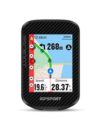
The iGPSPORT BSC300T Wireless Bike Computer GPS is ideal for avid cyclists, including road bikers, mountain bikers (MTB), and e-bike riders who seek reliable navigation and performance tracking. Those who value a combination of touchscreen convenience and physical button control, along with compatibility with action cameras like Insta360, will find this device especially beneficial.
Pros:
- Wireless connectivity for easy installation and clutter-free setup
- Touchscreen combined with button controls for versatile operation
- Offline MAP navigation with off-course warning enhances route guidance
- Compatible with Insta360 for seamless action camera integration
- Compact dimensions suitable for various bike types including e-bikes, road bikes, and MTB
Cons:
- Limited color options (Touch Screen & Button only)
- Relatively larger height dimension may affect aerodynamics slightly
The iGPSPORT BSC300T features an intuitive touchscreen interface paired with physical buttons, ensuring reliable and flexible control in all riding conditions. Its wireless design means you can mount it effortlessly without worrying about tangled wires or complicated installation, making it perfect for both casual and serious cyclists. The device’s compact size fits comfortably on handlebars of various bike types, including e-bikes, road bikes, and mountain bikes.
One of the standout features is the offline MAP navigation system, which provides accurate routing even without cellular service, coupled with an off-course warning to keep riders on track. The compatibility with Insta360 cameras allows riders to capture immersive footage while easily monitoring their ride data. Overall, this bike computer enhances both safety and riding experience through its smart navigation and user-friendly controls.
To buy this product, click here.
4. Garmin Montana 710

The Garmin Montana® 710 is ideal for outdoor enthusiasts, hikers, hunters, and professionals who require a reliable and rugged GPS handheld navigator. If you need a device with a large, glove-friendly touchscreen that performs well in harsh environments and offers detailed satellite imagery and maps for both road and trail navigation, this device is tailored for you.
Pros:
- Large 5-inch touchscreen that is glove-friendly, ensuring easy use in all weather conditions.
- Rugged design built to withstand tough outdoor environments.
- Detailed satellite imagery and maps for precise routing on roads and trails.
- Compact and lightweight with dimensions of 3.4 x 1.3 x 7.2 inches and weighing only 0.90625 pounds.
- Reliable brand and manufacturer, Garmin, known for quality GPS technology.
Cons:
- Relatively higher price point compared to basic GPS devices.
- Screen size may be too large for users seeking a more compact device.
- Battery life can be affected by extensive use of satellite imagery features.
The Garmin Montana® 710 stands out with its robust construction and a large 5-inch glove-friendly touchscreen, making navigation effortless even in challenging outdoor conditions. The touchscreen is responsive and designed to be used with gloves, which is a significant advantage for users in cold or rugged environments. Its detailed satellite imagery and comprehensive maps provide accurate routing, allowing users to explore both roads and trails confidently.
Additionally, the device’s compact size and lightweight design ensure it won’t weigh you down during long excursions. Garmin’s reputation for durable and precise GPS devices is well reflected in the Montana® 710, making it a trusted tool for adventurers and professionals alike. Whether you are hiking through forests or navigating unfamiliar terrain, this handheld navigator delivers reliable performance and convenience.
To buy this product, click here.
5. Beeline Bike Gps Computer – Velo 2

The Beeline Bike GPS Computer – Velo 2 is ideal for avid cyclists and outdoor enthusiasts who need a reliable, easy-to-use navigation device. If you are someone who enjoys long rides, exploring new routes, or requires accurate global navigation with minimal hassle, this weatherproof and glove-friendly GPS computer is designed for you. Its compact size and long battery life make it perfect for daily commutes as well as extended adventures.
Pros:
- Wireless Global Navigation Map for seamless route tracking
- Weatherproof design ensures durability in all conditions
- Long battery life of 11+ hours supports extended rides without recharging
- USB charging for convenient power on the go
- Glove-friendly interface for easy use while cycling
- Includes a strap mount for secure attachment to your bike
- Compact and lightweight for minimal bulk during rides
Cons:
- Screen size may be small for users who prefer larger displays
- Limited color options available (only black)
- Advanced navigation features might require some initial learning
The Beeline Velo 2 offers cyclists a highly functional GPS computer that combines simplicity with essential navigation capabilities. Its wireless global navigation map allows riders to explore new routes confidently without relying on their smartphones. Thanks to its weatherproof construction, this device withstands rain, dust, and rough handling, ensuring reliable performance in all environments. The glove-friendly touch interface enhances usability, letting users operate the device easily even in cold weather or with gloves on.
Battery life is a standout feature, providing over 11 hours of continuous use, which is ideal for long-distance cyclists and touring enthusiasts. The included strap mount ensures the GPS computer stays securely attached to the bike frame, reducing distractions and improving safety. Additionally, USB charging compatibility means riders can recharge conveniently on the go, making it a practical companion for both casual and serious cyclists. Overall, the Beeline Bike GPS Computer – Velo 2 is a compact, durable, and user-friendly device that enhances navigation and cycling experiences.
To buy this product, click here.
6. Gila Wilderness West

The Gila Wilderness WEST – New Mexico Hiking (2023) map is perfect for avid hikers, outdoor enthusiasts, and adventurers planning to explore the stunning trails of the Gila Wilderness in New Mexico. If you are someone who values detailed trail information and durable, portable maps to enhance your hiking experience, this item is an excellent choice. It is ideal for both seasoned hikers seeking new challenges and beginners who want reliable navigation in the wilderness.
Pros:
- High-quality, detailed trail mapping from the trusted Outdoor Trail Maps brand
- Compact and lightweight design (only 0.090 lbs), making it easy to carry during hikes
- Durable material suitable for outdoor use, resistant to wear and tear
- Accurate and up-to-date 2023 edition ensures current trail information
- Colorful and clear layout enhances readability and navigation
Cons:
- Limited to the western region of the Gila Wilderness, not covering the entire area
- Physical map format may not appeal to users who prefer digital navigation tools
The Gila Wilderness WEST – New Mexico Hiking (2023) map offers a blend of precision and convenience, crafted by Outdoor Trail Maps. Its compact dimensions of 7.0 inches by 4.0 inches and a thickness of 0.2 inches make it incredibly portable without sacrificing detail. Hikers benefit from the map’s comprehensive trail information, which aids in safe and efficient route planning across the diverse terrain of the Gila Wilderness. The mixed color scheme enhances trail visibility and helps users quickly identify key landmarks and pathways.
Beyond just navigation, the map supports a more immersive hiking experience by highlighting points of interest and critical natural features. Its durable construction ensures it withstands the elements, which is crucial for outdoor usage. For those who prefer tangible resources over digital devices, this map provides a reliable and practical solution, allowing users to focus fully on the adventure without worrying about battery life or signal issues.
To buy this product, click here.
7. Outdoor Trail Maps Llc Lost Creek Wilderness

The Outdoor Trail Maps LLC Lost Creek Wilderness – Colorado Topographic Hiking Map (2022) is ideal for avid hikers, outdoor enthusiasts, and adventure seekers who explore the Lost Creek Wilderness area. If you value detailed, reliable navigation tools for your hiking trips and want to enhance your outdoor experience with precise topographic information, this map is designed for you.
Pros:
- Highly detailed full-color topographic map for accurate navigation
- Compact and lightweight dimensions (7.0 x 4.0 x 0.2 inches) for easy carrying
- Produced by Outdoor Trail Maps LLC, ensuring quality and updated 2022 information
- Durable material suited for outdoor use and rough conditions
Cons:
- Limited to the Lost Creek Wilderness area, not suitable for other regions
- Physical map requires care to avoid damage from water or tearing
- May not include real-time trail updates compared to digital alternatives
This topographic hiking map offers a comprehensive view of the Lost Creek Wilderness terrain, highlighting elevations, trails, water sources, and landmarks in vivid full color. Its detailed contour lines help hikers understand the landscape better, enabling safer route planning and navigation. The map’s compact size and durable build make it convenient to carry on any hike without adding bulk or weight to your gear.
Users benefit from the latest 2022 updates by Outdoor Trail Maps LLC, ensuring that trail information is current and reliable. The clear, vibrant printing enhances readability even in bright outdoor conditions. Overall, this map serves as an essential tool for anyone seeking to explore Colorado’s Lost Creek Wilderness with confidence and ease.
To buy this product, click here.
8. Garmin Edge® Explore 2

The Garmin Edge® Explore 2 Power is an ideal GPS cycling navigator for avid cyclists, eBike riders, and outdoor enthusiasts who seek an easy-to-use device with advanced navigation and safety features. It is perfect for those who want to enhance their cycling experience with reliable maps, seamless route tracking, and compatibility with eBikes, making it a versatile tool for both casual riders and serious adventurers.
Pros:
- Easy-to-use interface with intuitive navigation controls
- Compatible with eBikes, enhancing functionality for electric bike riders
- Preloaded maps for accurate and reliable route guidance
- Built-in safety features to ensure rider security during rides
- Compact and lightweight design for convenient handling and portability
Cons:
- Limited color options, available only in white
- Relatively small display size may be challenging in bright sunlight
- Battery life may vary depending on usage and GPS activity
The Garmin Edge® Explore 2 Power stands out with its comprehensive mapping and navigation capabilities, providing cyclists with turn-by-turn directions and detailed route planning. Its eBike compatibility allows users to monitor battery life, speed, and other essential metrics, creating a seamless integration between the rider and their electric bike. The device’s compact dimensions and lightweight build make it highly portable without compromising functionality.
Safety is a core feature of this GPS cycling navigator, offering incident detection and assistance functionalities that can notify emergency contacts in case of an accident. The device’s bright and clear display ensures that users can easily read maps and data even in varied lighting conditions. Overall, the Garmin Edge® Explore 2 Power delivers a robust and user-friendly experience for cyclists looking to navigate with confidence and stay connected on their rides.
To buy this product, click here.
Frequently Asked Questions
What Features Do Garmin Huntview Maps Offer For Hunters?
Garmin HuntView Maps provide detailed 24K topographic maps, public and private landowner data, hunting zones, and trail information. They come preloaded on a microSD card, ensuring easy compatibility with Garmin handheld GPS devices. These features help hunters plan and navigate hunting trips effectively.
How Does Garmin Edge® Explore 2 Support Ebike Navigation?
The Garmin Edge® Explore 2 offers easy-to-use GPS navigation with dedicated eBike compatibility. It includes detailed maps, route planning, and safety features like incident detection. This device helps cyclists and eBike riders navigate trails and roads confidently with real-time guidance.
What Makes Garmin Montana® 710 Suitable For Outdoor Adventures?
Garmin Montana® 710 features a rugged design, a large 5-inch glove-friendly touchscreen, and satellite imagery. It supports routing on roads and trails, making it ideal for hiking, hunting, and outdoor navigation in challenging environments.
How Accurate Is The Igpsport Bsc300t Bike Gps Computer?
The iGPSPORT BSC300T offers precise GPS tracking and touchscreen offline map navigation. It provides off-course warnings and supports multiple cycling types, including eBikes and mountain bikes, enhancing ride safety and route accuracy.
What Benefits Does Beeline Bike Gps Computer Provide Cyclists?
Beeline Bike GPS offers wireless global navigation, weatherproof design, and over 11 hours of battery life. Its glove-friendly interface and included strap mount make it a reliable, easy-to-use navigation tool for cyclists in diverse conditions.
Are There Specialized Trail Maps For New Mexico And Colorado Hikers?
Yes, specialized maps like Gila Wilderness WEST for New Mexico and Outdoor Trail Maps Lost Creek Wilderness for Colorado provide detailed topographic hiking information. These maps help hikers navigate trails safely with up-to-date and accurate terrain data.
Conclusion
Choosing the right trail map or GPS device can make your outdoor adventures safer and more enjoyable. Devices like the Garmin HuntView and Montana 710 offer detailed maps and user-friendly features for hikers and hunters. For cyclists, the Garmin Edge Explore 2 and Beeline Bike GPS provide reliable navigation and long battery life.
Offline maps, touchscreens, and compatibility with eBikes add convenience on the go. Paper maps like the Gila Wilderness and Lost Creek Wilderness remain great backup options for those who prefer traditional navigation. Whatever your activity, having accurate maps and a good GPS helps you stay on track and discover new paths.
Remember, preparation is key to a successful trip. Take time to learn your device’s functions and study your map before heading out. With the right tools, every trail becomes an opportunity for adventure and discovery. Safe travels and happy exploring!